 |
|
|
#1 |
|
Senior Member
Join Date: Jun 2009
Posts: 108
|
Newps 8/7
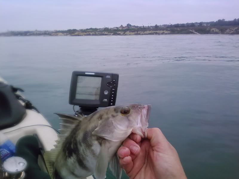
Headed south of Newport harbor on Sat. around 7. Plenty of bait to be made just outside the harbor in about 50 ft (lots of mini to large macks). Started heading south in about 80 ft of water trolling a mini mack on a ringed hook with egg sinker, spectra and fluorocarbon, when I got a nice bite. I reached back, put the reel in free spool, took the pole out of the holder and let the fish run with the bait. Started counting 1...2...3... then the fish really started peeling line off so I threw it in gear, bracing myself for the instant bendo. As soon as I set the hook I hear something break the surface and I look up to see a pup thresher flying through the air...awesome! Worked him to the boat in short order and made an attempt at a pic. The little guy decided he had enough and made a good run. I let him take some line as I enjoyed my first real sleigh ride (it was more like doing doughnuts). Worked him back to the boat again for another attempt at a pic, went to grab a glove and the little guy finally broke through my fluoro leader. The rest of the day was somewhat slow. I caught a nice sandy when I dropped an iron on some interesting marks. That fish was released as well. Highlights of the day were my first thresher and amazing performance of my Hbird 728. Now I know what you guys are talking about when you say you can spot your iron on the screen...totally cool! -Chris |
|
|

|
|
|
#2 |
|
Senior Member
Join Date: Jun 2009
Posts: 108
|
fish porn
Attempt at thresher pic
 Tady 45 Sandy 
|
|
|

|
|
|
#3 |
|
Senior Member
Join Date: Jun 2010
Location: Murrieta, CA and Bonney Lake, WA
Posts: 432
|
Fish Newport
I am off next week. I think i will come down and try outside of Newport. Any tips for launching, parking?
|
|
|

|
|
|
#4 |
|
Senior Member
Join Date: Apr 2010
Location: garden grove
Posts: 308
|
take 55 fwy till it ends on newport blvd.turn left on pch follow all the way till it almost ends in a residental area there is a small beach with a small life gaurd tower on left side of street between houses. it is a short paddle to bait barg and mouth of harbor.parking is free but can get crowed on street get there before 8 am and you should be cool.
|
|
|

|
|
|
#5 |
|
Senior Member
Join Date: Jun 2010
Location: Murrieta, CA and Bonney Lake, WA
Posts: 432
|
Great
I will check my honey do list and hit up Newport!! Thanks for sharing.
|
|
|

|
|
|
#7 |
|
Member
Join Date: Jun 2009
Location: Rancho Cucamonga, CA
Posts: 82
|
Now I'm totally confused...(looking to get a newport launch area as well).
In looking at Google Maps, it shows Balboa Blvd curving into Channel Rd., which ends at 'Jetty View Park'. Is that where you're talking about? I didn't see any parking there. If not, could you guys take a sec and look at Google Maps and stear us closer with street names? Sure appreciate it!. Mike |
|
|

|
|
|
#8 |
|
Daddeo
Join Date: Jul 2010
Location: OC
Posts: 660
|
Try the Penninsula side of the Harbor.

|
|
|

|
|
|
#9 |
|
Senior Member
Join Date: Jun 2009
Posts: 108
|
Mike,
You will see the beach and private dock on your left before you hit channel rd. You can't park directly in front of the beach because it's a red curb (bring wheels) and there is a concrete retaining wall that has stairs for low tide. |
|
|

|
|
|
#10 | |
|
Senior Member
Join Date: Apr 2010
Location: garden grove
Posts: 308
|
your welcome
Quote:
|
|
|
|

|
|
|
#11 |
|
Member
Join Date: Jun 2009
Location: Rancho Cucamonga, CA
Posts: 82
|
Does 'X' Mark the Spot?
Is the 'x' where you're talking about for launching? Call me blind....but I don't see the parking for it. Is it just really small and right there by the pier?
Also, where's the bait barge from there? Thanks! Mike |
|
|

|
|
|
#12 |
|
Junior
Join Date: May 2010
Posts: 13
|
The pier and the left beach is public, the right beach is private. Park in the neighborhood. You can find parking within view of the put-in before 8 am. Drop off your yak and park. Then drag your yak 20 ft to the retaining wall. The retaining wall is ~3ft so bring a towel to drape over the wall if you don't want to scrape up your yak. The bait barge is 1/4 mile down the jetty. You can't miss it.
|
|
|

|
|
|
#13 |
|
Member
Join Date: Jun 2009
Location: Rancho Cucamonga, CA
Posts: 82
|
Thanks!
Cool. If you park in the neighborhood, is there any 'thursday parking trap' type rules like La Jolla, or can you park all the time?
Mike |
|
|

|
|
|
#14 |
|
Senior Member
Join Date: Jun 2005
Location: Grants Pass, OR
Posts: 1,906
|
Or, Launch from the Harbor Patrol Beach.
__________________
Amish Ed You can't catch it again if it's dead! |
|
|

|
|
|
#15 |
|
Senior Member
Join Date: Jan 2009
Location: Rancho Cucamonga
Posts: 753
|
I talked to OCSD Harbor patrol the other day. Construction will continue into 2011, which really sucks - new docks and retaining wall. However, the construction is not effecting the parking and the beach is still open. Like Ed said, launch here!
__________________
GO ARMY BEAT NAVY! Bad decisions make great stories! 
|
|
|

|
|
|
#16 |
|
Senior Member
Join Date: Jun 2010
Location: Under a bridge
Posts: 2,169
|
Go to the Coast guard beach
You are better off launching from the Balboa side of the channel. You have nice free parking at the Coast guard beach, protected sandy beach and no wall to worry about. You do not have to worry about whether the tide is in or not. The little beach that was mentioned earlier in the post can be a little tricky with a crowd of moms and kids and the high tide right up to the wall. Take PCH south from 55 over the large PCH bridge and first major right on Bayside, follow this for about a mile and a half. Keep your eyeys open the entry to the Coast guard parking is easy to miss on the right. You will need some wheels to go over the sand. You are 5 mion. from the bait barge. Let us know how you did.
|
|
|

|
 |
| Thread Tools | |
| Display Modes | |
|
|