
 |
|
|
|
|
#1 |
|
Bad Clone
Join Date: Sep 2005
Posts: 874
|
The IPA maps
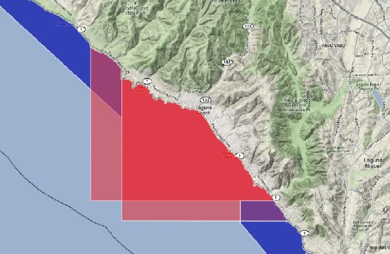
Since everyone is asking exactly what got recommended, here are the IPA maps in the disputed regions. I only put up maps in kayak interested areas. This is not the whole array of closures. I didn't put up the Laguna map since I don't know the area that well and I think they moved the boundaries a little bit and the marine map version isn't updated yet.
All this information is unofficial. Just what I understood from the meeting. I hope this clears up any confusion about what exactly was proposed. Doom, I mean Dume: No useful H&L in the blue. They changed the boundary between the blue and red a little bit, but it doesn't really matter since no useful fishing is allowed for us anyways. 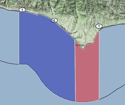 PV: 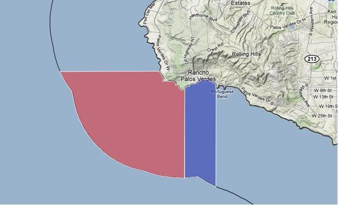 Swamis/Encinitas, no H&L fishing in this one. 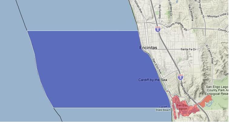 LJ 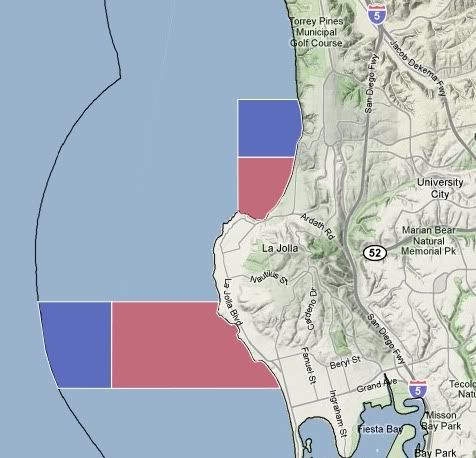 The south reserve starts at about Winamar Street at Wind and Sea, and almost goes to Crystal pier. The blue area is supposed to allow pelagic take. 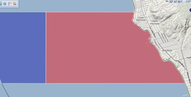 The blue area along Blacks Beach allows bait to be caught only. 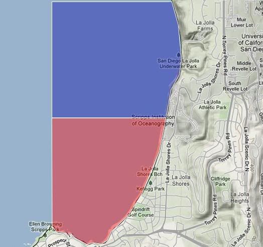 Literally cutting the Scripps Pier in half 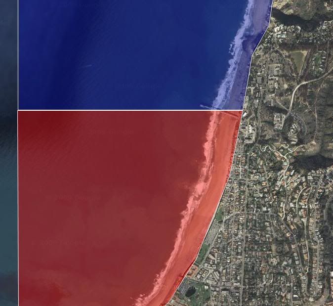 For comparison, the old and new LJ boundaries: 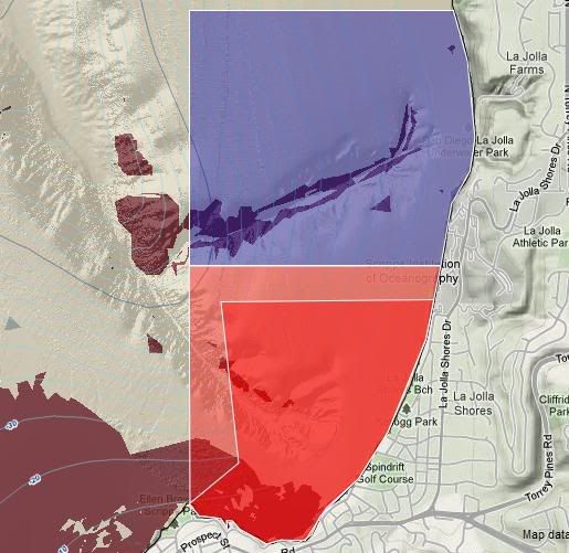
__________________
MLPA, if you are not part of the solution, you are part of the problem Let the Fish and Game Commission know what you think about the proposed maps. Be ready for December 9th and 10th. 
Last edited by tylerdurden; 11-11-2009 at 09:52 PM. |
|
|

|
|
|
#2 |
|
Member
Join Date: Apr 2009
Location: Anaheim
Posts: 85
|
Laguna got royally thrown under the bus to make up what they did not take in PV
__________________
Thanks, Jeff |
|
|

|
|
|
#3 |
|
BRTF...bought & paid...
Join Date: Mar 2005
Posts: 1,247
|
Thanks for that Tyler
LJ N of Scripps, we get phooked...any guys who fish the area care to respond? Looking at Swamis N, bug trappers get phooked. Plan to fish Cardiff? Drag the fish S to the 'free' space. LJ S ? Only to a certain spot, they do manage to wipe out the shallow water spots. Incredible. Let's see how they enforce the regs at night during bug season in the shallow areas that produce the best at S LJ/N PB. There has got to be some sort of compromise in those areas, and a compromise N of Scripps. If the boaters can't get in tight to those areas and only yakkers and spearos can, clarify then. Make amends. Yakkers and spearos will not damage/interfere/compromise/affect the natural habitat...and will not disrupt. Our catch is limited to our capacity. We need to and will inform the DFG of this...
__________________
Adios Tman Gaffer for Clay the Fishcatcher 
|
|
|

|
|
|
#4 |
|
fishy
Join Date: Sep 2005
Location: San Diego
Posts: 219
|
My be-loved La Jolla & Scripps. Where I have spent most of my life in the waters.
Sad day. Keep fishing guys.
__________________
warbaits.com Instagram @warbaits |
|
|

|
|
|
#5 |
|
Bad Clone
Join Date: Sep 2005
Posts: 874
|
Which one of those Laguna shapes did they take? The one further to the south I thought?
All the best shore fishing too. We can still lobby the DFG commission to allow shore fishing as I beleive the level of protection would still be unchanged. I think I forgot to mention shore fishing in my public comments for this area.
__________________
MLPA, if you are not part of the solution, you are part of the problem Let the Fish and Game Commission know what you think about the proposed maps. Be ready for December 9th and 10th. 
|
|
|

|
|
|
#6 |
|
Spam Sanitation Dept
Join Date: Jan 2007
Posts: 1,377
|
tragedy

|
|
|

|
|
|
#7 | |
|
Member
Join Date: Apr 2009
Location: Anaheim
Posts: 85
|
Quote:

__________________
Thanks, Jeff |
|
|
|

|
|
|
#8 |
|
Member
Join Date: Mar 2005
Location: La Jolla
Posts: 46
|
Going Green (Not)
[QUOTE=[I]Tman;47173]LJ N of Scripps, we get phooked...any guys who fish the area care to respond?[/I]QUOTE]
I fish there a lot, mostly for quality YT. Usually on my skiff, but sometimes on my kayak. Bait only?! So we paddle (or power) to the Scripps pier to make bait, then go -- how many miles? -- to use it. What ever happened to the "green" agenda (e.g. saving fuel and energy)? This is bullshit and serves no rational purpose. |
|
|

|
|
|
#9 |
|
Junior
Join Date: May 2009
Posts: 19
|
You guys use a langauge that's all your own. Talk like a normal guy and the normal guy would be more prone to help out.
Blue means Red means H&L is |
|
|

|
|
|
#10 | |
|
Señor member
Join Date: Mar 2005
Location: San Diego, CA
Posts: 1,627
|
Quote:
 BLUE = STATE MARINE CONSERVATION AREA (SMCA) limited-specific take RED = STATE MARINE RESERVE (SMR) NO TAKE H&L = HOOK AND LINE Last edited by Holy Mackerel; 11-18-2009 at 10:07 AM. |
|
|
|

|
 |
| Thread Tools | |
| Display Modes | |
|
|